


A Futuristic Marriage: Spy Satellites and Virtual Reality Could Pair to Aid Field Agents

U.S. government diplomats, officials and soldiers are often deployed to far-flung regions of the world and need to relay to officials back in Washington what they are seeing on the ground. Often, this is done via secure cables and electronic communications.
However, at some point in the future, those in the field could send back images that their stateside counterparts can access via virtual reality — letting them get a realistic look at what conditions are like on the ground using a VR headset. The agency that uses spy satellites to gather information and images from around the globe could be a key part of that effort.
Though it’s in the early stages, Nextgov reported last month that conversations “have just started” between National Geospatial-Intelligence Agency (NGA) immersion researchers and the agency’s mobile application developers to merge VR and mobile apps, according to Joe Wileman, a researcher at NGA.
Bridging the Gap with VR
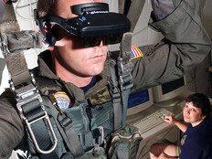
At NGA’s headquarters in Springfield, Va., emerging technology developers are experimenting with Oculus Rift VR headsets and other gadgets to push the boundaries of the agency’s tech ambitions.
Before, as Nextgov notes, those in the field could use a tripod-mounted scanner to take images that would then be composited into a 3D-panoramic view. However, using a smartphone camera and mobile apps, users can take photos of wherever they are —perhaps a streetscape somewhere, which could then be loaded into a generic building model at NGA. “We can then take those images and then overlay them on top of the building, so that our model becomes now the actual building,” an unnamed agency researcher who spoke on background told Nextgov.
Wileman said an American embassy employee based in Nepal, for example, could use such technology to bring a Federal Emergency Management Agency official into a disaster zone if another earthquake shook the country, as occurred in April 2015.
Or perhaps, “we can't afford to send somebody to Mogadishu [who can] walk around and see what it really looks” like, but “we may have somebody in a consulate who is in there who can take the day and take photos” to send those images back, another unnamed researcher told Nextgov.
What are the practical implications of such technology? Beyond relaying information about, and conditions of, a foreign location, it could help intelligence analysts assess whether or not it is safe for certain individuals to be in a specific area, or how intelligence officers could avoid detection, Nextgov notes.
In June, Lenovo released the PHAB2 Pro, billed as the world’s first Tango-enabled smartphone to enable augmented reality experience. Project Tango, which Google first unveiled in early 2014, lets mobile devices quickly and easily make a 3D map of an indoor space using 3D motion tracking and depth sensing.
Yet, as Nextgov notes, it’s unlikely that NGA will be rolling out similar gadgets in the near future, thanks to rigorous data security requirements imposed by the Department of Defense and the intelligence community. Still, it seems possible VR and spy satellites could be married at some point in the future.